Band 5.5 IELTS Writing Task 1 Model Answer
Overall Band Score: 5.5 · Cambridge IELTS 12 · 2026-11-11
IELTS Writing Task 1 question
The maps below show the centre of a small town called Islip as it is now, and plans for its development.
Summarise the information by selecting and reporting the main features, and make comparisons where relevant.
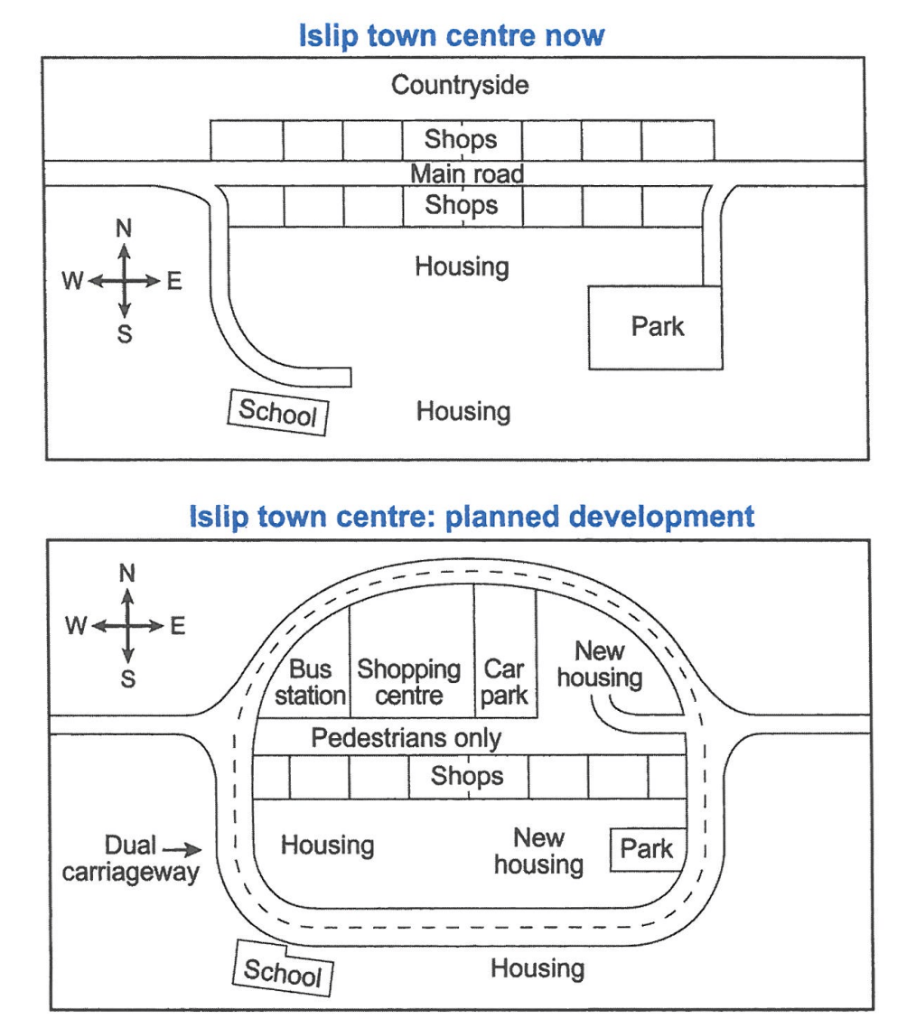
Student answer (Band 5.5)
The maps depicts the present Islip town and the future development of Islip town.
Overall,the Islip town have shops,park,schools and residential are in its center.And its planning for re-development in future,Including new housing for local residents,bus station and car parking is the major planing to develop.
At present,Islip town has a main road from the west to east side of the site,including two short connecting roads,there are several shops both sides of the main road,housing sites are at the center and south side of the map,there is also a school for childrens west side of the site connecting short road to the main road.Moreover,there is a public park for the residents at the east side of the map connecting with short road to the main road.
After re-development,main road divides into dual carriageway roads,at the north side of the map,there will be a bus station,a shopping center and a car parking at a row,east side inside the road is for new housing,center of the site is for pedestrains only,south side of the pedestrin walkway is for row shops,at the south west there will be old housing and new housing and park is at the south east side of the map.Outside of the dual carriageway at the south side there will be scholl and housing.
AI examiner evaluation
| Criterion | Band |
|---|---|
| Task Achievement / Task Response | 5.5 |
| Coherence and Cohesion | 6.0 |
| Lexical Resource | 5.0 |
| Grammatical Range and Accuracy | 5.0 |
| Overall | 5.5 |
Task Achievement / Task Response: Band 5.5
You identify the main purpose of the maps and report several important changes, including the pedestrian-only central street, the new bus station and shopping centre, and the dual carriageway. The overview also recognises that new housing is planned. However, some details are inaccurate or unclear: the present map has a school to the south-west, not simply on the west, and the planned bus station, shopping centre and car park are arranged west to east, a relationship your description does not make fully clear. The overview also says the town has a park and schools in its centre, which misrepresents their locations. To strengthen the response, give a more precise overview of the major transformation and compare what is retained, replaced and added.
Coherence and Cohesion: Band 6.0
The response has a recognisable structure: an introduction, an overview, a paragraph on the current layout and one on the proposed plan. This gives the reader a generally coherent route through the information, and phrases such as “At present” and “After re-development” help distinguish the two maps. However, several long sentences pack many locations together, making relationships harder to follow; for example, the final paragraph moves from the northern facilities to the pedestrian street and then to the southern areas in one extended sequence. Some linking is also mechanical, as in “Moreover.” Use shorter, clearly organised sentences and group features by area or by change to make comparisons easier to track.
Lexical Resource: Band 5.0
You use relevant map vocabulary, including “main road,” “dual carriageway,” “pedestrians only,” “residential,” and “connecting roads,” so the reader can understand the general development. However, the range is limited and several word choices or forms are inaccurate or repetitive. “Car parking” is less precise here than “car park,” while “short connecting roads” could be described as side roads. There are also noticeable spelling errors, including “pedestrains,” “pedestrin,” and “scholl,” and repeated use of “site” and “side.” These slips sometimes slow the reader. Build a more precise set of location and change expressions, and proofread spelling and word forms before submitting.
Grammatical Range and Accuracy: Band 5.0
You attempt some longer sentences and use present and future forms to distinguish the existing map from the plan. However, the range is limited, and complex sentences are often faulty or difficult to follow. For example, “The maps depicts” has subject–verb disagreement, while “the Islip town have” also uses the wrong verb form. Missing or incorrect articles and sentence boundaries appear in phrases such as “at a row” and “center of the site is for pedestrains only.” Commas are frequently used where a full stop would make the meaning clearer. Practise accurate subject–verb agreement, articles and complete sentence construction, then use a few controlled complex sentences to describe locations and planned changes.
See this exact question answered at other band scores. The same prompt compared across bands.
Browse more IELTS Writing model answers or get your own writing scored by the same AI examiner.