Band 5.5 IELTS Writing Task 1 Model Answer
Overall Band Score: 5.5 · Cambridge IELTS 12 · 2026-11-15
IELTS Writing Task 1 question
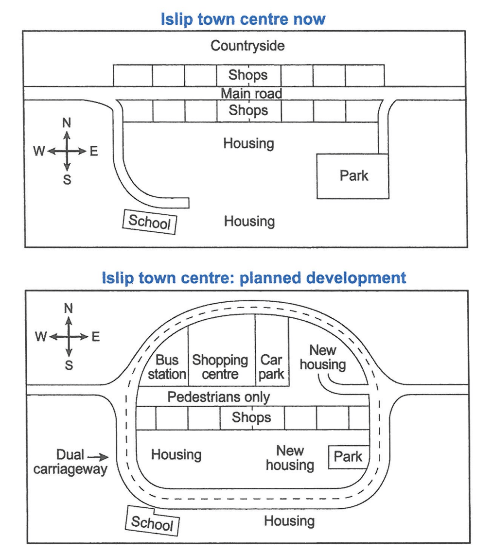
The maps below show the centre of a small town called Islip as it is now, and plans for its development.
Summarise the information by selecting and reporting the main features, and make comparisons where relevant.
Student answer (Band 5.5)
The given figure illustrates the developmental program for Islip town center.Utilising the space better is main goal for this plan.All these features will sort places and make it more organized.
Currently, the structure is very basic and plan.It reflects that area and development grew without any proper developmental strategy. Main road passed through town at the center connecting two sides from east towards west. Road is surrounded by shops both ways all along.By the north side of road after shops is the countryside area.And by the south side of road just after shops is the housing society.Housing society has a school at its south west side and a park for housing community at south east side.Park is also connected to main road.
New developmental plan changes the trajectory of road.Now instead of passing through the middle of everything,it goes outwardly with dual carriageway.North side now have a bus station,shopping center,car parking followed by new housing.after that towards south there are more lanes of shops but in between first a pedestrian lane is also passing. Towards south of shops is again houisng society with almost same placement of school and park.
New plan is more managed with creating less rush and excluding road from market place making it more peacful enviromeny.
AI examiner evaluation
| Criterion | Band |
|---|---|
| Task Achievement / Task Response | 6.0 |
| Coherence and Cohesion | 6.0 |
| Lexical Resource | 5.5 |
| Grammatical Range and Accuracy | 5.0 |
| Overall | 5.5 |
Task Achievement / Task Response: Band 6.0
You cover both the current layout and the proposed changes, and you identify the main transformation: the central road is replaced by an outer dual carriageway while the central route becomes pedestrian-only. You also report the new bus station, shopping centre and car park, so the response is relevant and includes key features. However, some details are inaccurate or unclear. The school and housing remain outside the new loop to the south, rather than having “almost same placement” within the redeveloped area; the park is reduced in size, and new housing is added in more than one location. The opening claims about better use of space and organisation are plausible, but the maps do not establish these as explicit aims. A more precise overview and clearer comparisons would make the account more complete.
Coherence and Cohesion: Band 6.0
The response has a generally understandable sequence: it introduces the plan, describes the present town centre, and then explains the proposed layout. This gives the reader a basic progression through the maps. Paragraphing also separates the current and future arrangements. However, some links are mechanical or unclear, particularly the repeated use of “And” and “after,” and the long final paragraph combines several locations without consistently signalling their positions. Phrases such as “North side now have” and “after that towards south” make the spatial relationships harder to follow. Use clearer location-based transitions, such as “to the north of the pedestrian street” and “south of the shops,” and group features by area. This would make the organisation more controlled and the comparisons easier to track.
Lexical Resource: Band 5.5
You use a reasonable range of topic vocabulary, including “dual carriageway,” “pedestrian lane,” “trajectory,” and “developmental strategy,” and the reader can generally understand the intended changes. However, several choices are imprecise or unnatural for describing maps. “Trajectory of road” does not clearly describe the road’s new route, while “housing society” and “car parking” are less suitable than standard map terms such as “residential area” and “car park.” There are also noticeable spelling errors, including “houisng,” “peacful,” and “enviromeny,” which reduce accuracy. Prefer concise, conventional geographical language and check spelling carefully. More precise terms would help distinguish the existing housing, new housing, and the reduced park.
Grammatical Range and Accuracy: Band 5.0
You attempt both simple and more complex sentences, including “Now instead of passing through the middle of everything, it goes outwardly with dual carriageway.” The overall meaning is usually recoverable, but errors in sentence structure, agreement, articles and punctuation occur across the response. For example, “North side now have” needs an article and subject–verb agreement, and “Main road passed through town” needs more accurate article use and tense. Several sentences also run together because spaces after full stops are missing, as in “center.Utilising” and “everything,it.” The final sentence, “New plan is more managed with creating less rush,” has an awkward grammatical construction. Review articles and agreement, and use shorter, complete sentences when describing each map feature.
See this exact question answered at other band scores. The same prompt compared across bands.
Browse more IELTS Writing model answers or get your own writing scored by the same AI examiner.