Band 6.5 IELTS Writing Task 1 Model Answer
Overall Band Score: 6.5 · Cambridge IELTS 12 · 2026-11-20
IELTS Writing Task 1 question
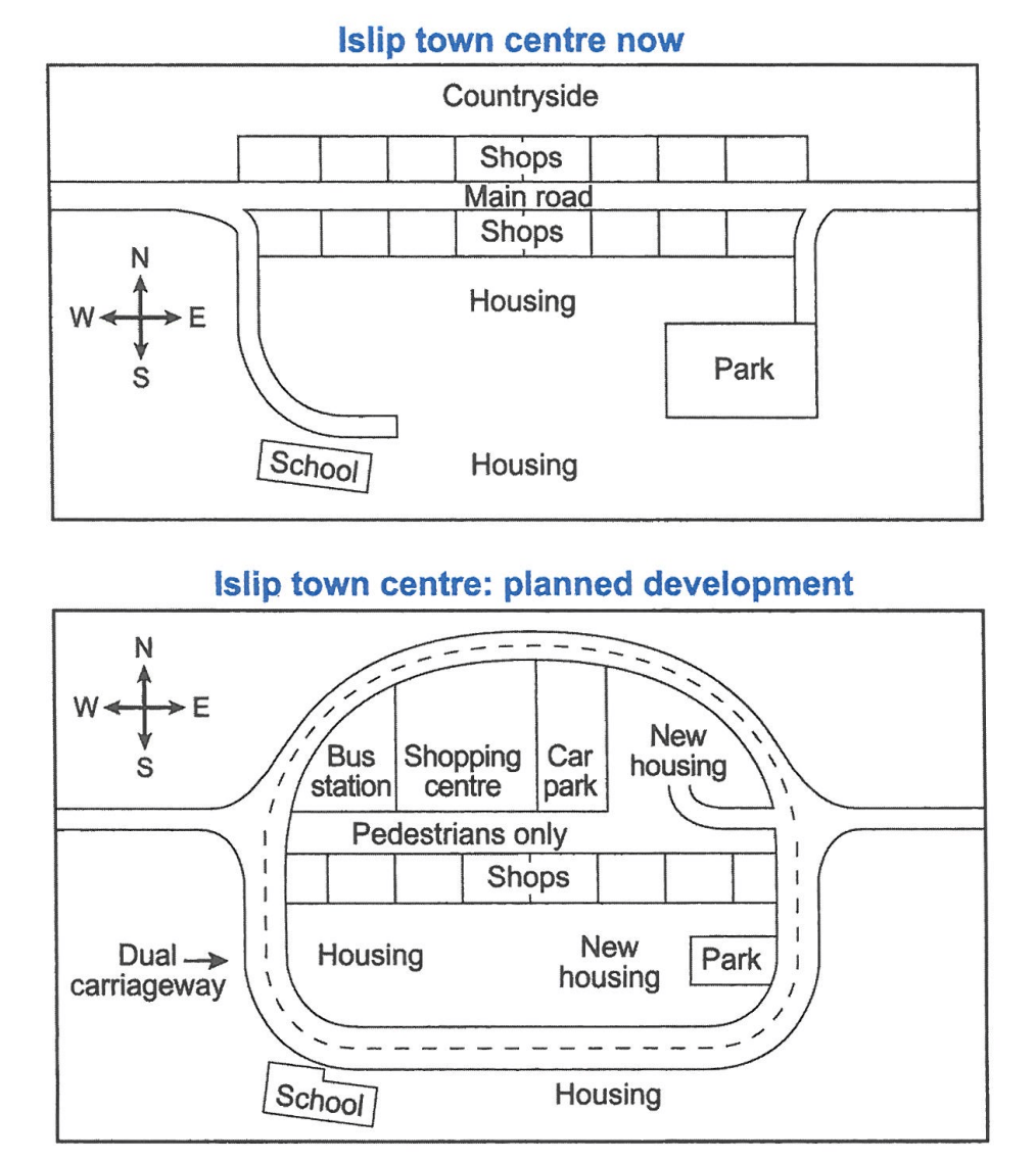
The maps below show the centre of a small town called Islip as it is now, and plans for its development.
Summarise the information by selecting and reporting the main features, and make comparisons where relevant.
Student answer (Band 6.5)
The map illustrates the layout of the small town Islip in present and the proposed plan for its development.
Overall, Islip is going under major development transforming from simple town to developed urban area. There are some facilities add in the town like new houses, pedestrian walk, shopping center and the town will be surrounded by the dual lane road.
Looking first at present map, the road running east to west from the center of the town and the shops are located along with road on both side. On the south side of the town there is a school which is connected by the small road to the main road ,while the housing is in the next to the school and behind the shops in the south. In addition, park is on the south east side of the town and a path is connected with main road.
Turning towards future planning of the town, the dual carriageway will be build around the town. On southern part of the town the school, park and housing will remain unchanged. However, new housing will be constructed next to the park. A new shopping center will be introduced on the north side of the map along with bus station on the west and car park on the east side of the shopping center. In the center of the map there will be pedestrians walk for people.
AI examiner evaluation
| Criterion | Band |
|---|---|
| Task Achievement / Task Response | 6.5 |
| Coherence and Cohesion | 7.0 |
| Lexical Resource | 6.0 |
| Grammatical Range and Accuracy | 5.5 |
| Overall | 6.5 |
Task Achievement / Task Response: Band 6.5
The response gives a clear overview of substantial change, identifying the new dual carriageway, pedestrianised central route and added facilities. It also compares the current and planned layouts and includes relevant locations, such as the bus station west of the shopping centre and the car park to its east. This covers the main purpose of the maps. However, some details are inaccurate or insufficiently developed: the school, park and housing are not all unchanged, since the park becomes smaller and some housing is replaced by new housing; the school and southern housing remain outside the carriageway loop. The northern new housing and the retained southern shops are also omitted. More precise coverage of these changes would make the summary more complete.
Coherence and Cohesion: Band 7.0
The response is organised into a brief introduction, an overview, and separate paragraphs for the present and planned layouts. This creates a clear progression, and signposts such as “Looking first” and “Turning towards future planning” help the reader follow the comparison. Information is generally grouped by map and location. Some links between details could be more precise: for example, “the housing is in the next to the school and behind the shops” makes the spatial relationship difficult to follow, while the future paragraph moves from the southern area to the north and then back to the centre. Grouping planned features consistently from north to south, and using clearer references to the map’s areas, would make the progression smoother. Overall, cohesion is effective, though some transitions and references remain slightly awkward.
Lexical Resource: Band 6.0
There is an adequate range of vocabulary for describing maps, including “layout,” “proposed plan,” “located,” “constructed,” and “surrounded.” The writer also uses relevant directional language such as “east to west,” “south side,” and “north side.” Some attempts at more specific expressions are imprecise or unnatural, including “going under major development,” “pedestrian walk,” and “dual lane road”; these reduce precision even though the intended meaning is usually understandable. Repetition of “town,” “road,” and “side” also limits flexibility. Use standard map vocabulary and more exact terms for changes and locations, such as “undergoing redevelopment,” “pedestrianised street,” and “dual carriageway,” while varying repeated nouns where appropriate.
Grammatical Range and Accuracy: Band 5.5
The response uses a mix of simple and complex sentence forms, including clauses introduced by “while” and “However,” and most relationships remain understandable. Some grammatical errors persist, particularly in verb forms, articles, and sentence construction. For example, “Islip is going under major development” and “the dual carriageway will be build” have incorrect verb forms; “in present” needs an article, and “the housing is in the next to the school” has a faulty construction. There are also punctuation and spacing problems, such as the space before the comma in “main road ,while.” These errors do not generally prevent understanding, but more consistent control of tense and sentence patterns is needed. Proofread each sentence for a complete, correctly formed clause.
See this exact question answered at other band scores. The same prompt compared across bands.
Browse more IELTS Writing model answers or get your own writing scored by the same AI examiner.